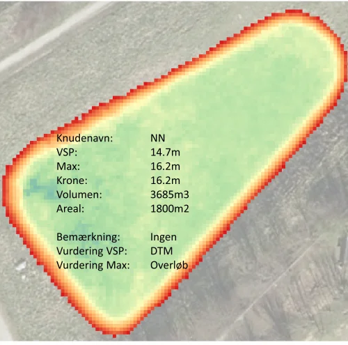
LNH water offers digital measurement of open rainwater basins for use in calculating basin volumes and height-area curves. The survey is exclusively digital and is carried out by analyzing data from Denmark’s Elevation Model (DK-DEM). The digital survey is primarily carried out using QGIS.
DK-DEM includes a larger (and increasing) number (+10 in 2020) of closely related elevation data products, which vary according to the primary purpose of use, including DHM/Terræn which is used as basic data for the digital measurement of open rainwater basins. The data collection for DHM/terrain is carried out by airborne Light Detection and Ranging (LiDAR) measurements. Information on terrain elevations is collected for approx. 4-4.5 points per square meters, which gives an average spatial resolution of approx. 0.4 m for the resulting data products. Measurements with LiDAR are made by calculating the time it takes high-frequency pulses (which are emitted from the sensor on the surveying plane) to hit an object on the surface and return to the laser. The time can then be converted to distance and height above sea level since the flight height is known.